Bali Pass trek

5

Bali Pass trek

Duration :   8 Days 7 Nights
The Price :   16,950.00
Max People :    20
Age Range :   18 - 63

Bali Pass is a mountain pass that peaks slightly short of 5000 meters mark, and connects the Har Ki Dun – Ruinsara Valley to Yamunotri and vice-versa. The trek runs through numerous heritage Villages of Har Ki Dun valley such as Osla, Gangaad, Taluka and ascends deep into the Govind National Park. On the route we come across the beautiful Ruinsara Lake. Multiple Waterfalls lie on the way to the pass.

Bali Pass trek distance is 66 KM from Taluka to Janki Chatti. The trek is on the difficult end as Bali Pass trek altitude is more than 16000 feet and has long walking days, with steeps ascents and descents. If one plans to attempt Bali Pass trek solo, it is highly advised to trek along a route guide as it is easy to misjudge the trail while descending or ascending the pass, with steep sections which can cause mishaps.

How to plan Bali Pass trek?


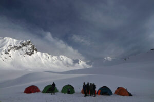
The pass is more approachable from the Har Ki Dun valley as the gradient is less steep and gives good time for the trekkers to acclimatize to the altitude. Although a few trekkers start the trek from Yamunotri too, which is not generally recommended. It is because the altitude gain from Yamunotri is very quick and the steep trail cab quickly tire trekkers. It can even lead to acute mountain sickness as there is barely any acclimatization to the high altitude. The route from Sankri has multiple campsites on the route and the itinerary can be easily changed as per convenience of trekkers. Generally the pass is attempted from Thanga, situated at 4100 meters. However, we can push to camp further at the base camp at a whopping 4,600 meters of altitude. This reduces the strain for the pass crossing day and further gives a unique experience of camping at a very high altitude. The Swargarohini has astounding views from the Bali Pass basecamp.

What makes Bali Pass trek a great choice?


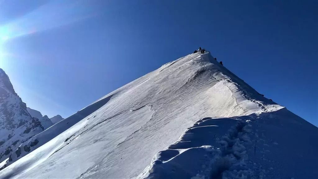
Bali Pass trek has a lot to offer apart from its virgin trails and a challenging pass climb. We are surrounded either by the mighty Swargarohini or Bandarpunch ranges at almost all times. We get to see Kalanag (Black Peak) & Swargarohini Peak up close. At 6,387 meters, the Kalanag peak is highest in this region. This peak was first summited by Jack Gibson in 1955 and the students of Doon school. We spend a day beside the Ruinsara Lake. The walk across the two meadows of Devsu Thatch and Thanga is breathtaking. One of our camps will be beside a waterfall and another one lies above 4,000 m. Wild animals such as Himalayan Ibex and Blue Sheep, Black Bears, Brown bears can be spotted occasionally on this trail! Our teams have sighted the Black bear on this trail ahead of Seema and near the waterfall camp, while the Brown bear was spotted near Thanga Campsite, and during an exploration towards Dhumdhar Kandi pass during the rest day at Ruinsara Lake. While the trail to Bali pass turns southward towards Yamunotri ahead of Ruinsara Lake, the eastward route continues to the challenging Dhumdhar Kandi. Its a daunting pass sharing its base camp with Black Peak and goes to Harsil. The Bali pass unlike a conventional pass, which means a saddle like opening between neighboring rising ridge, rises like a peak and gives a summit like adventure when you reach the top. The same can be visually seen in the summit stretch picture of Bali pass below. Towards the end of the Bali Pass trek, we see the Bandarpunch Glacier & Saptrishi Kund. They are the true source of river Yamuna. We also get an opportunity to visit the holy temple of Yamunotri. All in all, Bali Pass is a wholesome adventure that provides trekkers with every element of a Himalayan trek.

Bali Pass Trek


How difficult is Bali Pass trek?


Bali pass trek difficulty is based on the following factors – the pass has a maximum height (altitude) of 16,080 feet or 4,900 meters. The trek has a distance of 66 KM in total, starting from Taluka to the end point at Janki Chatti. It takes 6 to 7 days to complete the trek on foot. Thus we will walk around 10 KM on average everyday. The altitude of Taluka, where the trek starts from, is 6,825 feet (2080 meters). We thus have a net altitude gain of 9,250 feet (2,820 meters) over a duration of 5 days, thus climbing average of 550 meters a day or 1800 feet. That is a considerable altitude gain. The distance, altitude gain and finally the technical pass crossing make Bali Pass fall in the category of a Difficult trek. It requires physical preparation and regular exercises that must be started at least 1 month prior to trekking to the Bali Pass.

Check out Bali Pass Trek’s  Images.

Schedule Details

DAY 1

Drive from Dehradun to Sankri | Drive: 190 km; 8 hrs


Our journey begins from Dehradun, making it a good option for people looking for treks near Delhi. Driving alongside the Tons river, and passing villages in Uttarakhand like Damta, Purola, Mori, and Netwar, we will reach the base camp Sankri. There is no network in this village, letting us take in the sight of the sun gloriously setting over the surrounding Greater Himalayan peaks without any distractions. We will be accommodated in hotels or homestays here.

DAY 2

Trek from Sankri (1,920 m) to Seema (2,560 m) via Taluka (2,050 m) | Drive: 1 hr; Trek: 14 km; 5-6 hrs


Our journey begins from Dehradun, making it a good option for people looking for treks near Delhi. Driving alongside the Tons river, and passing villages in Uttarakhand like Damta, Purola, Mori, and Netwar, we will reach the base camp Sankri. There is no network in this village, letting us take in the sight of the sun gloriously setting over the surrounding Greater Himalayan peaks without any distractions. We will be accommodated in hotels or homestays here.

DAY 3

Trek from Seema (2,560 m) to Roiltia or Waterfall camp (3,350 m) | Trek 13 km; 6 hrs


Leaving the last of human settlements behind, we continue along the true left of the valley along the river Supin. Supin merges with Rupin near Netwar village to form Tons, which is the biggest tributary of river Yamuna. An ascend through deodar trees leads us to a beautiful meadow – Devsu Thatch. This 1km expanse of green land is set against the looming Swargarohini ranges. We can also see Kalanag (Black Peak) (6387m) straight ahead. On our left, we can see Har Ki Dun Valley. At its bottom lies the confluence of Har Ki Dun and Ruinsara rivers. After descending from the meadow, we enter the Ruinsara valley. At the end of today’s trek, we camp beside the stream close to the waterfall locally known as Roiltigad or Roiltia.

DAY 4

Waterfall to Ruinsara lake (3,600 m) | Trek: 4 km; 2 hrs


Today’s journey is going to take in under 2 hours even at a slow pace. And within this hike itself we notice a stark change in vegetation. Pine and fir trees give way to birch and rhododendron trees. The thick forest we trudge through is frequented by the endangered Himalayan brown bear. If we are very lucky, we might spot this rare and elusive creature. We then reach one of the highlights of the trek — Ruinsara Tal, an alpine tarn, surrounded by lush Rhododendron trees, with their distinct pink bloom in the summers. We will be left enchanted by this sacred lake in the Uttarakhand Himalayas. It is one of the trio of lakes in the Garhwal region, the other two lakes being Marinda and Maldaru. We will be camping overnight near the lake.

DAY 5

Ruinsara lake - rest and explore or Trek to Thanga | Trek: 3 km; 1.5 hrs


Lying at an elevation of about 3500 m, Ruinsara lake is a good place to acclimatize ourselves before reaching Bali Pass base camp the next day. Ruinsara Tal’s reputation precedes itself for its beauty. The small and pristine lake lies within a vast meadow, alpine vegetation and surrounding rhododendron bushes. There is innumerable variety of alpine flowers growing around the lake. The river Supin is situated 100 meters below the lake, next to a ridge. It is the perfect place to play games with our trek mates, read a good book or just sit quietly to soak in nature’s tranquillity. We can also spend the day exploring nearby places. One can trek towards the Banderpunch glacier or Kyarkoti which is the base camp for Kalanag and Dumdar Kandi pass. We return to the camp in the evening.

DAY 6

Ruinsara lake/Thanga to Bali Pass Basecamp (4,600 m) | Trek: 8 km; 7 hrs


We start the day early so as to reach our destination before afternoon. We descend down to the shallow river bed, cross over to the opposite bank and walk uphill to another beautiful meadow – Thanga. This meadow also offers awe-inspiring views of the seemingly omnipresent Swargarohini ranges. Kyarkoti valley lies towards the left.
We soon reach Odari. The word ‘Odari’ means a naturally made cave rock. This place has a mythological story associated with it. It is believed that Bali, Hanuman’s brother, had stayed here for one night. Here too we might find evidence of the rare Himalayan brown bear. We camp below Bali Pass along a glacial moraine. This is the one of the best locations for a camp, with the valley below and the Pass behind us. The temperatures at night tend to go to sub-zero degrees. Camping at this altitude is a unique experience which very few treks offer.

DAY 7

Bali Pass Basecamp (4,600 m) to Lower Dhamni (3,200 m) via Bali pass (4,900 m) | Trek: 12 km; 9 hrs


This day of crossing Bali Pass too begins very early. We strive to reach the summit by 8am. The trail heads down south, over a ridge. It is a fairly short but steep climb up to the Pass. A lot of glacial scree will be encountered here. Time taken to reach the top ranges from 45 minutes to one and a half hours.
Once we reach the top, we behold the Yamunotri valley for the first time. The view is breath- taking. We see hints of the Saptrishi Kund, which is the origin of river Yamuna. We also get to witness the Banderpunch peaks from the top of the Pass. The summits of Dayara Bugyal, Barua Top and Dokrani Bamak are visible too. We then descend carefully via a connecting ridge and reach the camping grounds of upper Dhamni.

DAY 8

Lower Dhamni to Yamunotri to Janki Chatti (2,400 m)| Trek: 12 km; 6 hrs


We descend further to a forested trail. This path leads us to the famous shrine of Yamunotri with the glorious Bandarpunch in its background. One of the temples in the Char Dham circuit, it is dedicated to Goddess Yamuna. After paying obeisance to her black marble idol, we make our way down the conventional pilgrim road to Janki Chatti. We stay overnight in one of the guesthouses here. We will get electricity but no phone network.

DAY 9

Drive from Janki Chatti to Dehradun | Drive: 190 km; 8 hrs


This is the final day of the trip and we drive back to Dehradun. We can make the most of this jourey by visiting other well-known places that fall on this route such as Kempty waterfalls, Nainbagh and Mussourie.
With equally beautiful memories of an offbeat trek and touristy sight-seeing, we have a cherishable experience.

Got a Question?